The steps that will be followed during MAIL are:
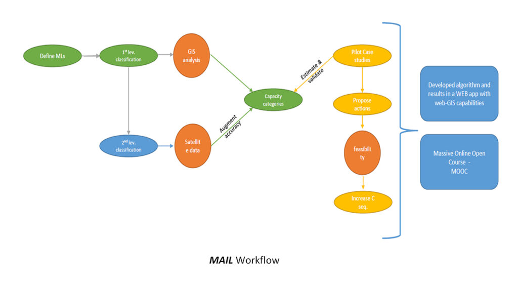
- Define MLs. The term ML from the perspective of cost-effective food production, is something dynamic, changing according to latitude.
- Determine the different ML types and the minimum requirements for their utilization as carbon sinks.
- Identify & assess all the potential datasets from other EU or global initiatives that could be used in order to locate MLs and produce marginality indicators based on characteristics such as acidity, salinity, lack of nutrients, organic matter, slope, aspect, etc.
- 1st level classification. Development of a methodology that allows identifying MLs based on available LULC information (Corine Land Cover, forest and agricultural inventories, cadastral cartographies, etc.)
- Establish 4 pilot areas based on the main biogeographical regions in Europe (Mediterranean, Atlantic, Continental, Alpine etc.).
- Evaluate 1st classification through field stratified sampling and further categorize MLs in Carbon sequestration capacity categories based on new and existing models.
- Augment accuracy, through 2nd level classification by the usage of full free and open access satellite datasets with enhanced spatial and radiometric resolution. Reclassify the detected ML areas in Carbon sequestration capacity categories. This information is not contained in the available LULC databases and the proper methodology does not exist.
- Estimate & validate CO2 sequestration models in pilot case studies where sustainable forestry activities will be implemented and their carbon stock will be estimated.
- Evaluate & compare certain RS data series with field data, in order to define the best possible way to map/monitor MLs.
- MOOC training of students, researchers and stakeholders in two thematic areas; RS as a tool to monitor and process MLs and Forestry as a tool to identify MLs and calculate their carbon sequestration capacity based on measuring/sampling/processing.
- Develop a web-application platform with web-GIS capabilities, which will provide:
- To experts: developed methodologies, algorithms and techniques for on-demand production of thematic maps within Europe.
- To land owners: MLs identification, Carbon sequestration capacitycategorization and proposition of alternative usages of low productivity lands (sustainable utilization) through feasibility studies, so that they can make a profit in the emerging Carbon Markets.
- Propose actions to increase the Carbon sequestration capacity and examine their feasibility so they can be implemented with a prudent and cost effective manner, as there is no European policy for their optimal management. Ancillary information about soils, slopes, orientation, hydrogeological data, etc. will be considered in the design of the proposed actions.